This historic Dhaka Map of 1859 ( City of Dacca ), printed by the Surveyor General of India in 1859, offers a rare and detailed visualisation of mid-19th century Dacca (now Dhaka), drawn to a scale of 12 inches to the mile. It captures a city that still retained the rhythms of a Mughal urban layout while slowly adapting to colonial influences.
The map shows the city’s built-up core hugging the northern bank of the Boorygunga (Buriganga) River, with neighbourhoods (mahallas) clustered around chowks and bazaars. On the eastern edge, urban sprawl reached only up to the Dulai Khal and Alamganj, while Ganderia and Narinda lay just beyond the city’s defined limits. To the west, the settlements of Nawabganj, Goaltoli, and Sonartoli marked the edge of habitation—beyond which there was virtually no development.
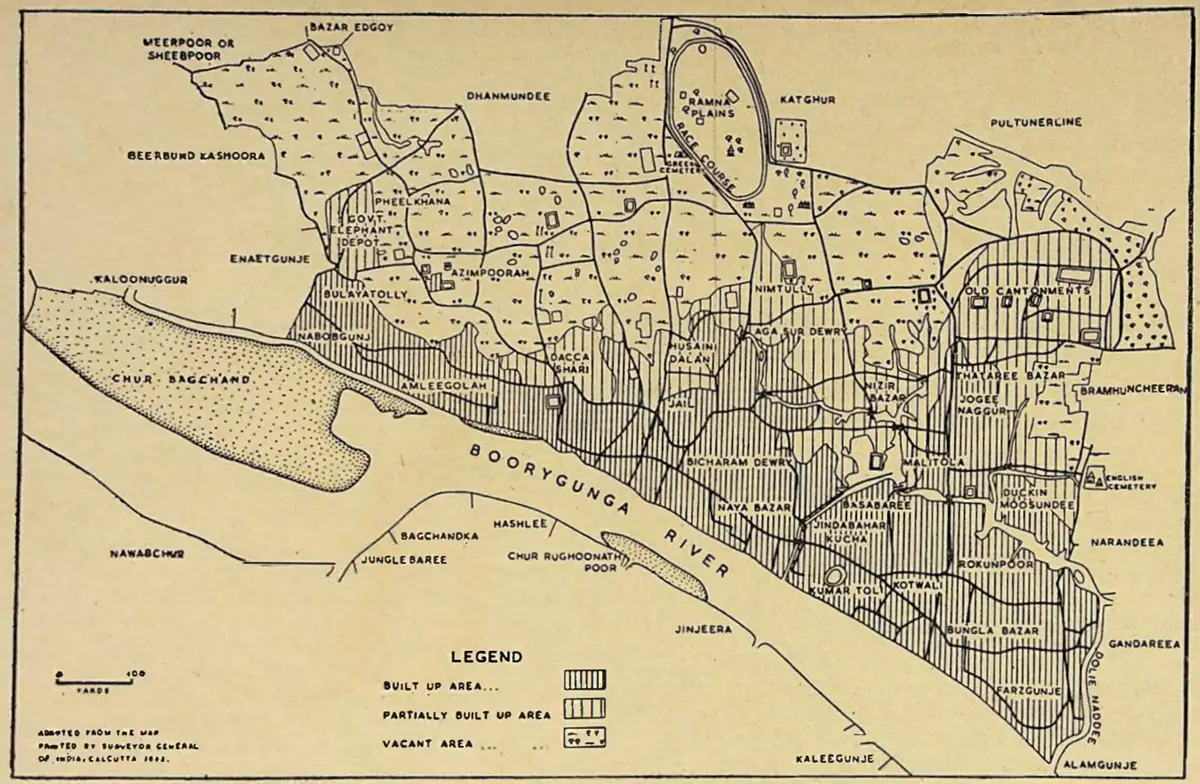
To the north, the map presents an oval-shaped Race Course and the wooded Katghar area, corresponding to today’s Ramna Park and adjacent roads like Minto, Bayley, and Hare. Dhanmondi, now a densely built area, appears as open paddy fields. Much of modern-day Ramna, including the University campus, Azimpur, and Pilkhana, was then a scrubland covered with vegetation.
A footnote to the map remarks that the expansive Buriganga during the rainy season lent Dhaka a dreamlike resemblance to Venice, its minarets and large structures seeming to rise from the water. The town spanned about 3 miles in length and 1 mile in breadth, featuring either brick houses or straw huts arranged along narrow, crooked streets. Only a handful of roads were metalled and wide enough for wheeled carts.
The city was interwoven with footpaths and ditches separating neighbourhoods. Two main streets intersected at what is today Victoria Park. The riverside road stretched over 2 miles from Lalbagh Fort to Dulai Khal, while the north-south axis reached from the Race Course to the Old Cantonment (now Purana Paltan).
Additional notes on the map highlight:
- Ten bridges over the Dulli Creek and its branches, including a notable iron suspension bridge built in 1830 through public contribution under Magistrate Walters.
- Seven main ghats and four licensed ferries facilitating riverine mobility.
- Twelve well-known bazaars, underscoring the city’s commercial vibrancy.
The map predates the construction of the railway line, which, after 1895, would reshape the city’s urban geography, creating a permanent divide between old Dacca and the newer colonial town of Ramna.
This map remains a crucial historical artifact, capturing the morphology, infrastructure, and lived geography of a city transitioning from its Mughal past into a colonial future.
Text: Shamsuddoza Sajen, Chief Archivist, Bangladesh on Record
Source: Azimusshan Haider, ed. A City and Its Civic Body: A Souvenir to Mark the Centenary of Dacca Municipality. Dhaka, June 1966.